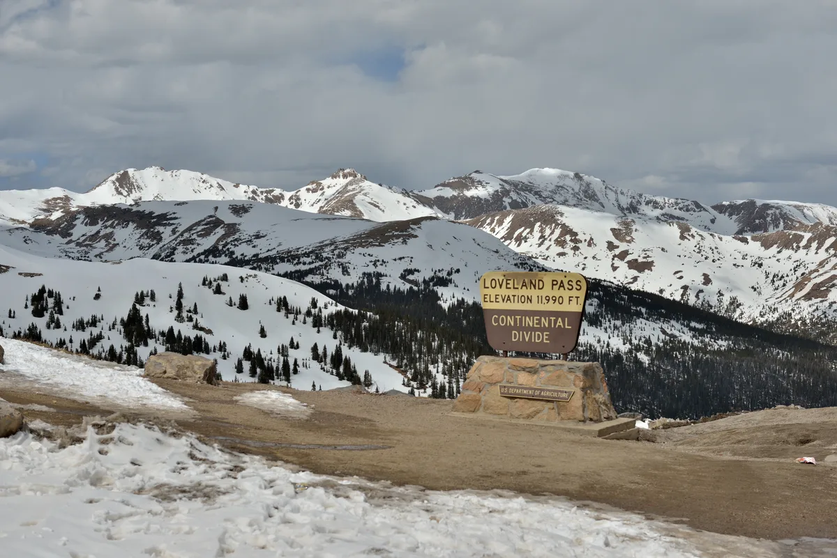
Loveland Pass
Keystone, CO
At 11,990 feet, this Continental Divide crossing on US Highway 6 provides 360-degree views of alpine tundra, distant peaks, and glacial valleys. The pass marks the boundary between Summit and Clear Creek counties and is one of the highest paved mountain passes in the United States. Cornices and snow formations persist along the ridgeline well into summer.
Photography Guide
- Best Time
- golden hour
- Crowds
- Moderate
- Shot Types
- widelandscapeastrophotography
- Best Seasons
- summerfallwinter
Is it a good day to go?
7-day outlookMild, dry days with light winds are the most comfortable for a visit.
Forecast by Open-Meteo. Verdicts weigh the forecast against the conditions that suit this spot.
Author's Comments
At nearly twelve thousand feet, you step out of the car and the air does what it always does up here. It thins. The light goes harder and cleaner than anything you find lower down, and the horizon in every direction is made of mountains. Loveland Pass is one of those places where the scale of the West stops being an idea and becomes something you have to physically adjust to. I come in late June for the cornices. The snow holds along the ridgeline well past when the valleys have gone green, and there is a window of maybe two weeks when you can photograph white curling formations against tundra already in bloom. The contrast is strange and wonderful. In September the light shifts again, the air dries further, and the distant peaks sharpen until they look almost cut from paper. Golden hour is the hour, but be honest about what golden hour means at this altitude. The sun drops behind a ridge and the temperature falls fifteen degrees in twenty minutes. Bring more layers than you think. Bring them in summer too. A word about afternoons. The monsoon builds fast here in July and August, and the ridgeline is exactly where you do not want to be when it does. I have watched a clear sky turn to lightning in under an hour. Shoot the morning, or wait until the storms have passed and come back for the last light. The pass rewards patience and punishes the impatient with weather you will remember. On clear nights the Milky Way arcs over the divide with almost no light pollution to interfere. That is its own pilgrimage and worth a separate trip.
Gallery
You might also like
Nearby Places
Keystone, CO
Keystone Lake and River Run Village
A small alpine lake at the base of Keystone Resort reflects the surrounding peaks and resort architecture. The lake freezes in winter and is maintained as a skating rink, creating unique nighttime photography opportunities with resort lighting. River Run Village offers European-inspired pedestrian streets with mountain backdrops.

Keystone, CO
Lily Pad Lake
A small, shallow alpine lake reached via a gentle 3-mile round trip trail through lodgepole pine and aspen forest near Keystone Resort. The lake surface is dotted with lily pads in summer, creating foreground texture for mountain reflections. Wildflowers line the trail in July, and moose are occasionally spotted in the wetlands near the lake.

Dillon, CO
Sapphire Point Overlook
A short 0.6-mile loop trail leads to a dramatic overlook perched above Dillon Reservoir with sweeping views of the Tenmile Range. The point is a popular wedding venue and offers unobstructed panoramic views in nearly every direction. The overlook sits along the Swan Mountain Road between Keystone and Breckenridge.